|
|
| Coast to Coast 2006 Homepage | Coast to Coast 2007 Photos | Coast to Coast 2006 Photos | Our Other Walks | Walking Places Message Board and Forum | Contact Us |
| DAY 1 | DAY 2 | DAY 3 | DAY 4 | DAY 5 | DAY 6 | DAY 7 | DAY 8 | DAY 9 | DAY 10 | DAY 11 | DAY 12 | DAY 13 | DAY 14 |
|
|
|
Grasmere to Patterdale DAY 4 – TUESDAY 12 JUNE Mileage 10 miles
Our decision to stay overnight in Grasmere was intended to give us a few short days and tackle one of the high level climbs to Patterdale – St Sunday’s Crag. Although there is a C2C alternative path mentioned in the books that goes across St Sunday’s Crag from Grisedale Tarn we checked the maps and found that there was another possible route that we could take from Grasmere – going up over Fairfield, via Arthurs Crag – so, the adventurous souls we are, we decided to opt for that.
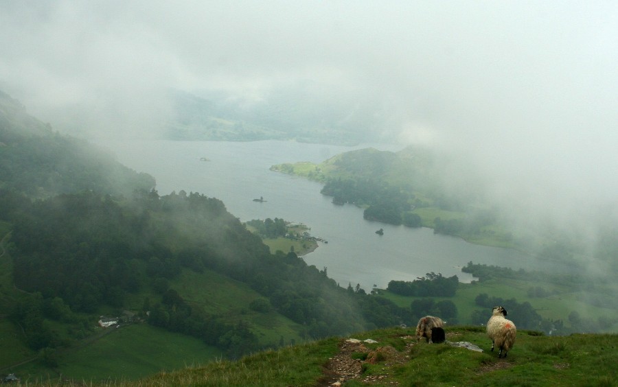
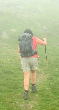
The weather had changed as predicted by the forecast we read earlier in the week. The sky looked very grey and threatening as we set off, being optimistic we left our waterproofs in our rucksack.
It had also started to rain, the waterproofs soon came out. We looked back down towards Grasmere, now shrouded in mist, before shouldering our rucksacks and heading on up. The cloud came down, we could not see anything and were still really unsure how near the top we were then suddenly the cloud lifted and we could see the large mass of Fairfield looming in front of us and Grisedale Tarn over to the left, the cloud descended again. Even though we were no longer following the C2C route we bumped into large groups of walkers coming the other way. We all looked at each other, recognising that we were mad to be out in such weather, smiling wryly and greeting each other as we battled against the elements. In a way it was good to be meeting 'regular' walkers and runners out for the day rather than coast to coasters. By now we were beginning to tire of the slightly sanitised, safe, follow the directions in the book approach and enjoying our slightly more adventurous journey. Several fell runners sped past, their legs bright red from the cold, they had decided to brave the weather in their little shorts.
Finally we reached the top of Fairfield, even if we couldn't see very well, we at least recognised this from a previous walking weekend around the Fairfield Horseshoe. A very scrambly climb followed down from Fairfield and back up to St Sunday Crag. Finally the cloud lifted, we could see the way we had come, quite good seeing that we had made the top of pretty large hill. The cloud lifted a little more, looming behind us was a big black mountain, all jagged, had we really just climbed over that?
Going against my better judgement, rather than turn back and walk back to the top (which at that stage was not too far away) to find the right path, we decided to continue downwards. By now the cloud was very dense and it was difficult to see more than a few meters ahead. I shouted at Kev to slow down as I was worried that he would disappear into the cloud, leaving me on my own. Kev continued on downwards, then suddenly fell. One minute he was standing up, the next he had slipped and landed on his backside. His hand went up to indicate there was no problem. Fortunately he was alright but it was a bit of a shock. I think it might have been the first time that I had ever seen him fall. There was no sign of the path leading over to the left – in fact our path looked like it was on the verge of disappearing altogether. Kev stopped at this point. He turned to me and to my surprise suggested phoning mountain rescue! “Why?” I asked confused. Although we were obviously on the wrong path, we had the GPS, we knew roughly where we were. Surely all we had to do was follow the path back up to the top and then use the GPS to find the right path? I wasn’t worried about the climb back up as we’d managed to climb down it fine. It seemed wrong to call mountain rescue without even making some attempt to solve the problem ourselves. The rain was pouring down, the visibility non-existent, but that didn’t worry me, as we had our GPS. Without it, it would have been a very different story. Kev reluctantly turned round and we made our way back up the path. Just before the climb started to get steep, Kev stopped. There was a path leading off to the right. Could it lead to the path we should have been on? We decided to risk it – neither of us had really been relishing a climb back up to the top at this stage of the day. We started to walk across a nice level path and a few minutes later I went head over heels and rolled over my trekking pole. Fortunately no damage as the ground was so wet. I chased along the path to catch Kev up, who had not noticed the fall. 10 minutes later the cloud lifted again, and we could see three walkers striding along a path – our path! We had been right after all. What a relief. The path down to Patterdale was now quite straight forward. Apart from a dodgy stile, which I nearly fell off in climbing over. A group of kids were on the other side having a rest. They had big rucksacks and were obviously planning some wild camping – as they headed upwards I thought – rather them than me – especially when the cloud came swirling downwards again.
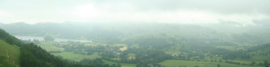
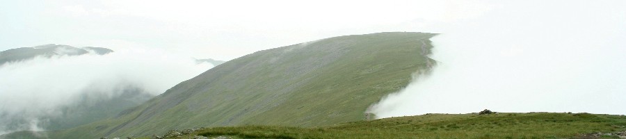
The view in the valley was now clear and we could see the path on the opposite side to us heading downwards from Helvellyn towards Glenridding. As there was a very nice cafe in Glenridding we decided to avoid Glenamara Park, and follow the road to Glenridding for a well earned cup of Hot Chocolate. Suitably refreshed and with Kev resisting the scrummy looking cakes, we headed back to our B&B at Patterdale – Old Water View – we had stayed here last year and knew that we would have somewhere nice and welcoming to rest after our day in the hills followed by a good dinner at the White Lion.
|
 The
path to Arthur's Crag soon started to climb steeply. We
noticed signs warning of difficult stretches and obstructions ahead
- the Lake District Park Authority were in the
process of repairing sections of the footpath and had air lifted
large bags of rock onto the hillside. We seemed to be
making very good progress, in fact we were really pleased with the
speed we had gone up to the top of the first hill but looking at the
map to check our position we became a little concerned there were streams where there
shouldn't be streams, they or us were in the wrong place. After a slight panic
thinking that we
had gone up the wrong path altogether, we eventually realised that
we were on the right path, just a lot, lot lower down than what we had
expected. Not as quick as we had originally thought and still a
long way from the real top of the hill, which by now was obscured in
mist.
The
path to Arthur's Crag soon started to climb steeply. We
noticed signs warning of difficult stretches and obstructions ahead
- the Lake District Park Authority were in the
process of repairing sections of the footpath and had air lifted
large bags of rock onto the hillside. We seemed to be
making very good progress, in fact we were really pleased with the
speed we had gone up to the top of the first hill but looking at the
map to check our position we became a little concerned there were streams where there
shouldn't be streams, they or us were in the wrong place. After a slight panic
thinking that we
had gone up the wrong path altogether, we eventually realised that
we were on the right path, just a lot, lot lower down than what we had
expected. Not as quick as we had originally thought and still a
long way from the real top of the hill, which by now was obscured in
mist. 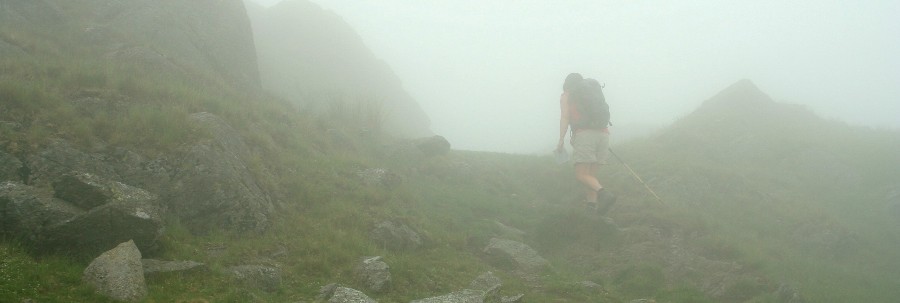
 The next objective was the summit
of St Sunday Crag. A nice walk along a fairly flat ridge and we
we were soon at the top. With the cloud coming down again it
was difficult to find the path we needed and we started to wander
around the summit plateau looking for signs of a path down. We took
what appeared to be a well used path down. B y now slightly
disorientated, Kev got the GPS out, which confirmed we were
not on the right path, however looking at the map, it seemed that if
we continued on, we would meet another path which we could follow to
get back
over to the right path.
The next objective was the summit
of St Sunday Crag. A nice walk along a fairly flat ridge and we
we were soon at the top. With the cloud coming down again it
was difficult to find the path we needed and we started to wander
around the summit plateau looking for signs of a path down. We took
what appeared to be a well used path down. B y now slightly
disorientated, Kev got the GPS out, which confirmed we were
not on the right path, however looking at the map, it seemed that if
we continued on, we would meet another path which we could follow to
get back
over to the right path.